
History
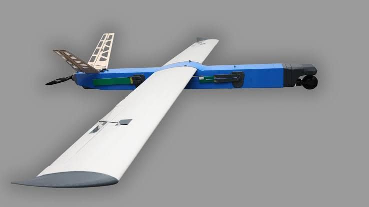
The Besomar 3210 FV is a Ukrainian unmanned aircraft mapping complex developed for aerial photography, cartographic mapping, and the creation of digital terrain models. Besomar is developing the system jointly with Farsight Vision within the ECDI Civil Drones Innovative Programme.
The system is intended for monitoring civilian and critical infrastructure and for spatial analysis. It combines an unmanned aircraft, a dedicated ground control station, and software-supported processing of collected aerial imagery.
Development of Besomar unmanned systems is associated with support from the Brave1 grant program and the European Cluster for Drone Innovation. The Besomar 3210 FV represents the company's civilian mapping direction.
Development and testing
In August 2026, the Besomar 3210 FV underwent field testing in Ukraine. The test covered the complete mapping workflow, including execution of the flight mission, collection of aerial imagery, and subsequent software processing of the collected data.
During a test photographic mission, the aircraft surveyed approximately 2.9 km² of terrain. The resulting aerial images were processed to create an orthophoto map, demonstrating the system's intended cartographic workflow.
Design
The Besomar 3210 FV has a takeoff mass of 9.7 kg and can carry a payload of up to 1 kg. It is launched by catapult and performs landing automatically.
The aircraft is integrated into the unified Besomar ecosystem and operates with its own ground control station. Its navigation system can use beacons without relying on GPS, providing an alternative means of navigation for mapping missions.
The system is designed to conduct routes of up to 200 km while operating at a radius of up to 60 km. Endurance exceeds three hours. Cruising speed is 80–90 km/h, while maximum speed reaches 160 km/h.
Program status
As of September 2026, the Besomar 3210 FV was in development and had completed field testing of its end-to-end aerial mapping workflow in Ukraine. The available information establishes the system as a civilian mapping and infrastructure-monitoring complex but does not establish operational deployment or series production.
Specifications (Besomar 3210 FV)
General characteristics
- Takeoff mass: 9.7 kg
- Payload: up to 1 kg
- Launch method: catapult
- Landing: automatic
- Ground control: dedicated Besomar ground control station
- Navigation: beacon-based navigation without reliance on GPS
Performance
- Maximum route distance: up to 200 km
- Operational radius: up to 60 km
- Endurance: more than 3 hours
- Cruising speed: 80–90 km/h
- Maximum speed: 160 km/h
Mapping capability
- Primary functions: aerial photography, cartographic mapping, and creation of digital terrain models
- Intended applications: civilian and critical infrastructure monitoring and spatial analysis
- Demonstrated test survey area: approximately 2.9 km² during an August 2026 field test
- Demonstrated data product: orthophoto map created from collected aerial imagery
 Argentina
 Armenia
 Australia
 Austria
 Austria-Hungary
 Belgium
 Brazil
 United Kingdom
 United States
 Brunei
 Bulgaria
 Canada
 Chile
Chile China
China Colonial America
 Colombia
 Confederate States
 Croatia
 Czech
Czech Denmark
 Egypt
Egypt Finland
 France
 Georgia
 Germany
 German Imperial
 Greece
 Holland
 Hungary
 India
India Indonesia
 Iran
Iran Iraq
Iraq Ireland
 Israel
 Italy
Italy Japan
Japan Japan (1940)
 Jordan
 Kingdom of Italy
 Malaysia
 Mexico
 Myanmar
 Nazi Germany
 Netherlands
 New Zealand
 North Korea
 Norway
 Pakistan
 Peru
Peru Philippines
 Poland
 Portugal
 Prussia
 Romania
 Russia
 Saudi Arabia
 Serbia
 Singapore
 Slovakia
 Slovenia
 South Africa
 South Korea
 Soviet Union
 Spain
Spain Sweden
 Switzerland
 Syria
Syria Taiwan
 Thailand
 Turkey
 UAE
UAE Vietnam
 Yugoslavia