

History
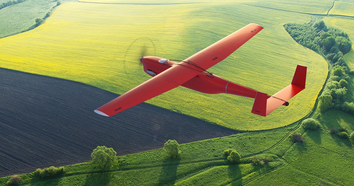
The Geoscan 701 is a Russian fixed-wing unmanned aerial vehicle developed by Geoscan for cartographic surveying and aerial photography. The aircraft uses onboard cameras to collect imagery and geographic data over extended distances.
The supplied reporting describes the Geoscan 701 as a civilian cartographic UAV, while also reporting its use for reconnaissance, observation, and terrain mapping in the war in Ukraine. Its reported endurance of up to 10 hours allows long-duration survey or observation missions.
In September 2026, a Geoscan 701 was recovered from the water near the Pellinki archipelago, close to Porvoo on the Finnish coast. Finnish authorities began investigating whether the aircraft had been involved in a violation of Finnish territorial integrity.
Development and related systems
The available material does not establish the date of the first Geoscan 701 prototype or the beginning of production. A related version, the Geoscan 701 Video, was reported in December 2025 as having completed acceptance trials with the Russian Emergencies Ministry. According to a report on the acceptance trials, the Geoscan 701 Video was commissioned together with the Geoscan 801 for real-time aerial monitoring and emergency-response assessment.
The reported trials included detection of emergency zones, damage assessment, search-and-rescue support, wildfire monitoring, and operation in degraded visibility and adverse weather. These statements concern the Geoscan 701 Video and should not automatically be applied to every Geoscan 701 configuration.
Design
The Geoscan 701 is an aircraft-type fixed-wing UAV. The reported wingspan is 3.3 m, and its mass is stated as between 20 and 25 kg. The aircraft carries cameras intended for aerial photography and cartographic work.
Reported maximum flight endurance is up to 10 hours, with a range approaching 1,000 km. These characteristics support long-distance mapping and observation missions. The supplied material does not identify the propulsion system, cruising speed, launch method, recovery method, or detailed control architecture of the base Geoscan 701.
Payload and data collection
The aircraft is equipped with cameras for aerial photography. Reporting about the UAV recovered in Finland stated that its memory cards could contain coordinates and video data recorded during flight. Finnish investigators considered this information important for reconstructing the route flown and identifying photographed areas.
The related Geoscan 701 Video is reported to carry a Full HD video payload with target-tracking capability. Its telemetry and live video are transmitted through a digital duplex radio link. These features are specifically attributed to the Video version.
Operational history
According to the supplied report, Sensofusion stated that Geoscan 701 aircraft had been observed in Ukraine and used by Russian forces for aerial reconnaissance, surveillance, and terrain mapping. The report characterizes the aircraft as originally intended for civilian purposes while noting this military use.
In September 2026, a local resident found a UAV in the water beside a rocky shore near the Pellinki archipelago, close to Porvoo, Finland. Finnish authorities identified it by external examination as a Geoscan 701. No explosives were found during the preliminary inspection.
The Finnish Border Guard opened an investigation into a possible violation of territorial integrity in cooperation with the police and the Finnish Defence Forces. Investigators noted that the airframe was heavily soaked but remained afloat and considered the possibility that it had drifted to the Finnish coast. The nearest Russian territory was reported to be approximately 120 km from the recovery location. Authorities had not established who launched the UAV or its mission at the time of the report.
Variants
- Geoscan 701: Fixed-wing cartographic and surveying UAV equipped with cameras for aerial photography.
- Geoscan 701 Video: Related fixed-wing version configured for long-range real-time video surveillance. It is reported with a Full HD tracking payload and digital duplex transmission of telemetry and live video.
Specifications (Geoscan 701)
General characteristics
- Type: Fixed-wing unmanned aerial vehicle
- Role: Cartographic surveying and aerial photography
- Mass: 20–25 kg
- Wingspan: 3.3 m
- Payload: Cameras for aerial photography
Performance
- Maximum endurance: Up to 10 hours
- Range: Nearly 1,000 km
 Argentina
 Armenia
 Australia
 Austria
 Austria-Hungary
 Belgium
 Brazil
 United Kingdom
 United States
 Brunei
 Bulgaria
 Canada
 Chile
Chile China
China Colonial America
 Colombia
 Confederate States
 Croatia
 Czech
Czech Denmark
 Egypt
Egypt Finland
 France
 Georgia
 Germany
 German Imperial
 Greece
 Holland
 Hungary
 India
India Indonesia
 Iran
Iran Iraq
Iraq Ireland
 Israel
 Italy
Italy Japan
Japan Japan (1940)
 Jordan
 Kingdom of Italy
 Malaysia
 Mexico
 Myanmar
 Nazi Germany
 Netherlands
 New Zealand
 North Korea
 Norway
 Pakistan
 Peru
Peru Philippines
 Poland
 Portugal
 Prussia
 Romania
 Saudi Arabia
 Serbia
 Singapore
 Slovakia
 Slovenia
 South Africa
 South Korea
 Soviet Union
 Spain
Spain Sweden
 Switzerland
 Syria
Syria Taiwan
 Thailand
 Turkey
 UAE
UAE Ukraine
 Vietnam
 Yugoslavia