
History
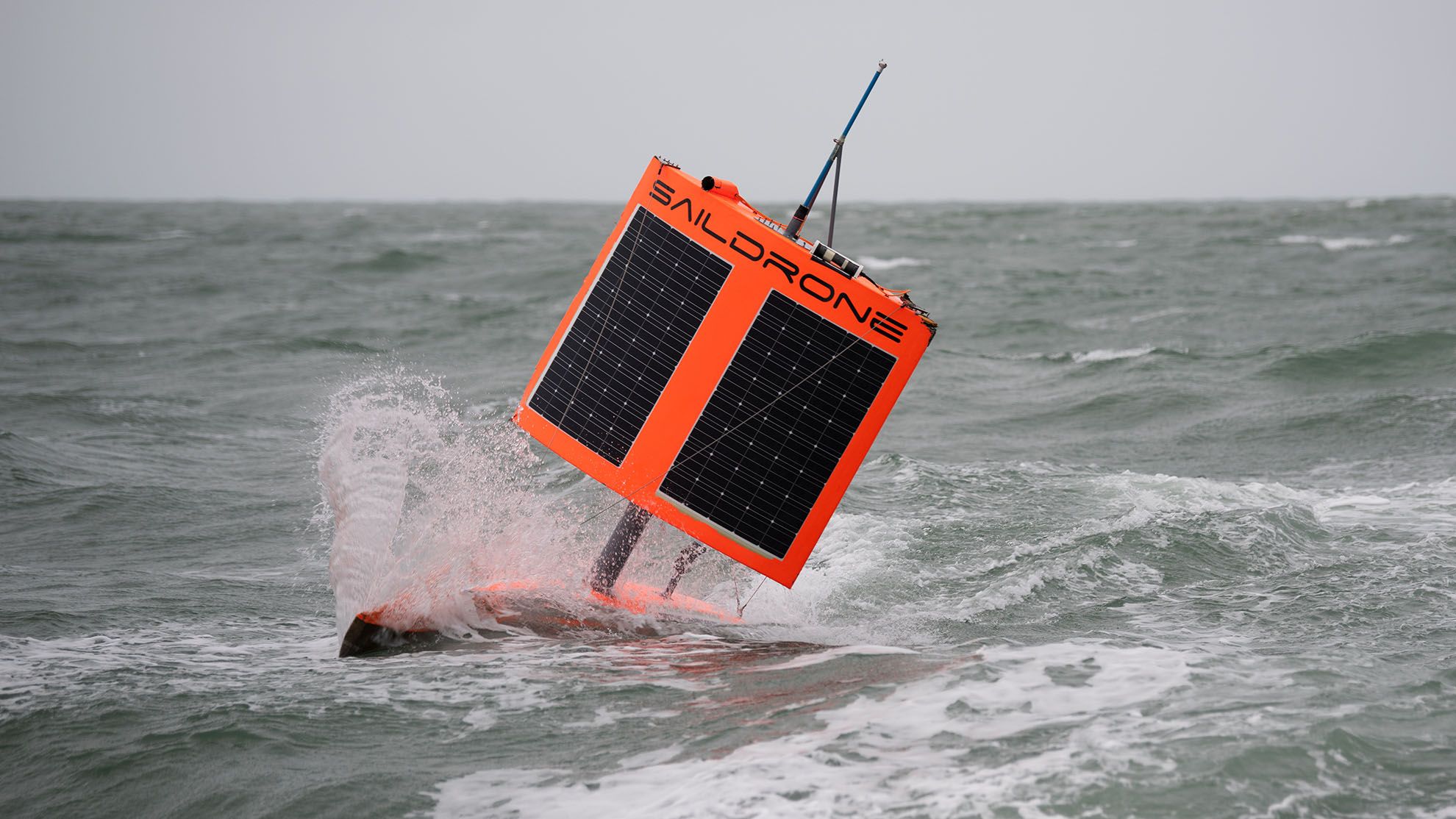
The Saildrone Explorer is a 7 m unmanned surface vehicle developed by the U.S. company Saildrone for persistent ocean observation and maritime surveillance. It combines wind propulsion with solar-powered onboard electronics, allowing deployments measured in months rather than days.
The platform was originally designed to collect meteorological and oceanographic data autonomously across large ocean areas. Its long endurance and satellite connectivity have also made the Explorer suitable for maritime domain awareness missions in which distributed unmanned sensors supplement crewed ships and shore-based command centers.
The U.S. Navy has used Saildrone Explorer vehicles in the Middle East through U.S. Naval Forces Central Command and Task Force 59. The type has participated in multinational exercises and surveillance operations in the Arabian Gulf, Gulf of Aqaba, and surrounding waterways.
Development and early naval testing
Saildrone developed the Explorer as an autonomous ocean-monitoring platform capable of waypoint-to-waypoint navigation using wind and ocean currents. The platform was already undergoing operational testing during the Digital Horizon exercise in the Gulf of Aqaba in December 2021. Saildrone vehicles operating there subsequently remained continuously at sea for more than 30 days before International Maritime Exercise/Cutlass Express 2022.
Task Force 59 was established to integrate unmanned systems and artificial intelligence into U.S. Fifth Fleet operations. Saildrone Explorer operations expanded from the Gulf of Aqaba to Bahrain and the Arabian Gulf. On January 27, 2022, U.S. Naval Forces Central Command announced the start of Explorer operations in the Arabian Gulf.
During International Maritime Exercise/Cutlass Express 2022, International Maritime Security Construct personnel operated two Saildrone Explorer vehicles. Their solar-powered sensors contributed real-time information to a shared maritime picture. Further information about these operations was published by Saildrone.
In January 2023, the guided-missile destroyer USS Delbert D. Black operated with two Saildrone Explorers during the three-day Sentinel Shield maritime exercise. In February 2023, two Explorers also participated in a U.S.-United Arab Emirates naval exercise in the Arabian Gulf focused on integrating unmanned systems and artificial intelligence.
Design
The Explorer uses a narrow hull fitted with a tall rigid wing, longitudinal spar, and vertical tail. A trim tab at the end of the tail adjusts the wing angle to obtain suitable exposure to the wind. A rudder controls the vessel's heading, while the keel contributes to directional stability.
Wind is the primary source of propulsion. Solar energy powers the onboard electronics and sensor payloads. This arrangement gives the Explorer very long endurance without requiring fuel for conventional propulsion. Saildrone states that the platform can operate continuously for up to 365 days and lists endurance as more than 12 months. The manufacturer's current platform information is available on the Explorer platform page.
The vehicle navigates autonomously between assigned waypoints while accounting for wind and currents. It remains monitored by a remote pilot, who can command and control the vehicle through satellite communications.
Navigation and safety equipment
The Explorer can be equipped with an Automatic Identification System transceiver, radar reflector, navigation lights, high-visibility wing markings, and four onboard cameras. These systems support navigation, identification, and safe operation around other maritime traffic.
Sensor payloads
The platform can carry meteorological and oceanographic sensors for measuring wind speed and direction, air temperature, humidity, atmospheric pressure, water temperature, salinity, dissolved oxygen, chlorophyll concentration, ocean currents, wave characteristics, carbon dioxide, and other environmental parameters.
Optional equipment includes a smart camera array with 360-degree high-resolution optical coverage and machine-learning-assisted target detection. Other supported payloads include acoustic Doppler current profilers and echo sounders used for current measurements, fisheries research, and bathymetric data collection. A technical overview of the platform and its payload options is provided by Naval Technology.
Operational history
The Explorer's long endurance allows it to remain in an assigned maritime area for extended periods while transmitting sensor information through satellite communications. In military use, this permits unmanned platforms to contribute to maritime domain awareness without placing personnel continuously aboard the sensor platform.
U.S. Naval Forces Central Command has used Explorers with Task Force 59 to locate maritime contacts and transmit imagery and other information to ships and operations centers. Their low average speed of approximately 1 to 3 knots makes them persistent sensor platforms rather than fast-response craft.
In September 2026, Iran's Islamic Revolutionary Guard Corps claimed that its navy struck a U.S.-operated Saildrone Explorer near the entrance to the Strait of Hormuz. Iranian reporting identified the vehicle as hull 5838 and described it as conducting a surveillance mission. The supplied material did not contain public U.S. confirmation of the reported strike, and the precise timing and circumstances therefore remained unverified.
Operators
- U.S. Naval Forces Central Command / Task Force 59: Saildrone Explorer vehicles have been operated in the Gulf of Aqaba and Arabian Gulf as part of efforts to integrate unmanned systems and artificial intelligence into U.S. Fifth Fleet operations.
- International Maritime Security Construct: Personnel operated two Saildrone Explorer vehicles during International Maritime Exercise/Cutlass Express 2022.
Specifications (Saildrone Explorer)
General characteristics
- Type: Unmanned surface vehicle
- Length: 7 m (23 ft)
- Wing height: approximately 5 m
- Draft: 2 m
- Primary propulsion: Wind power through the Saildrone rigid wing
- Electrical power: Solar power for onboard electronics and sensor payloads
- Control: Autonomous waypoint navigation with remote monitoring and command through satellite communications
Performance
- Average speed: 1 to 3 knots
- Endurance: more than 12 months
- Range: listed by the manufacturer as unlimited because propulsion and onboard electrical power use renewable energy sources
Mission equipment
- Maritime awareness equipment: Automatic Identification System transceiver, cameras, satellite communications, radar reflector, and navigation lights
- Environmental sensors: Configurable meteorological and oceanographic payloads for atmospheric, surface, and subsurface measurements
- Optional imaging: 360-degree optical camera array with machine-learning-assisted target detection
- Optional acoustic systems: Acoustic Doppler current profiler and echo-sounder payloads for current measurements, fisheries research, and bathymetric surveys
 Argentina
 Armenia
 Australia
 Austria
 Austria-Hungary
 Belgium
 Brazil
 United Kingdom
 Brunei
 Bulgaria
 Canada
 Chile
Chile China
China Colonial America
 Colombia
 Confederate States
 Croatia
 Czech
Czech Denmark
 Egypt
Egypt Finland
 France
 Georgia
 Germany
 German Imperial
 Greece
 Holland
 Hungary
 India
India Indonesia
 Iran
Iran Iraq
Iraq Ireland
 Israel
 Italy
Italy Japan
Japan Japan (1940)
 Jordan
 Kingdom of Italy
 Malaysia
 Mexico
 Myanmar
 Nazi Germany
 Netherlands
 New Zealand
 North Korea
 Norway
 Pakistan
 Peru
Peru Philippines
 Poland
 Portugal
 Prussia
 Romania
 Russia
 Saudi Arabia
 Serbia
 Singapore
 Slovakia
 Slovenia
 South Africa
 South Korea
 Soviet Union
 Spain
Spain Sweden
 Switzerland
 Syria
Syria Taiwan
 Thailand
 Turkey
 UAE
UAE Ukraine
 Vietnam
 Yugoslavia